
When your phone buzzes with a flood warning at 3 a.m., what actually decides if you should leave right now or wait until morning? The answer isn’t simple. Evacuation timing depends on a mix of what emergency managers see in their data (how fast water’s rising, which roads are still open) and what your household can realistically do (Do you have a car? Can your elderly parent travel? Where would you even go?). Some families in the same neighborhood leave two days early while others wait until water hits their porch, and it’s rarely about who’s smarter or braver. This guide breaks down the ten factors that determine flood evacuation decisions and timing so you can figure out your safest move before the next storm.
Key Categories That Drive Flood Evacuation Decisions

Flood evacuation decisions come down to two main groups: what officials see in their data and what individual families can actually do. Emergency managers look at physical threat levels and geographic weak spots to figure out when to tell people to leave. Families make their own calls based on what they’ve got, what they believe, and what’s holding them back.
Officials split their orders into mandatory evacuations, where you’re legally required to go, and voluntary ones, where they suggest leaving but don’t force it. That difference shapes how fast communities move.
Here’s what actually determines whether people evacuate and when:
Physical flood conditions: How high water’s predicted to rise, how deep it’ll get, how hard it’s raining, what kind of flood it is (flash, river, or coastal), and how long the storm lasts. All of this affects how urgent things are and when people need to move.
Geographic location and infrastructure: How high up you are, how close to water, which hazard zone you’re in, whether evacuation routes can handle the traffic, and if your building can take the hit. These determine both how bad your risk is and whether you can actually get out.
Official warning protocols: Emergency systems, how accurate predictions are, how much heads up you get, and how warnings reach people. This shapes when orders go out and who actually hears them.
Socioeconomic resources: Income, whether you own a car, if you can afford evacuation costs, if you rent or own, and whether you have flood insurance. These determine if leaving is even financially possible.
Demographic characteristics: Age, health issues, disabilities, who’s in your household, what languages you speak, and cultural background. Each creates its own set of obstacles or advantages.
Psychological responses: How you see the risk, whether you trust authorities, past flood experience, thinking it won’t happen to you, fear levels, and straight up denial. These influence whether you follow evacuation orders.
Shelter and accommodation options: Emergency shelters available, temporary housing capacity, whether they take pets, and worries about someone breaking into your property. All of this affects willingness to leave.
Timing windows: How much warning before flooding starts, whether it’s day or night, what season it is, and if multiple communities are evacuating at once. These determine your actual safe departure window.
Communication effectiveness: How clear warnings are, if messages stay consistent, media reach, social media spread, and language accessibility. This shapes how well evacuation information actually gets around.
Previous preparedness: Whether you’ve got an emergency plan, if you’ve done evacuation drills, knowing your routes, having supplies packed, and planning ahead. These cut down on how long it takes to make decisions.
Evacuation timing depends on multiple factors working together, not just one thing. A coastal household with a car, flood insurance, and a ready emergency kit evacuates differently than a low income renter with no transportation facing the same storm. Understanding these factors helps officials create better plans and helps households make smarter protective choices when water threatens.
Physical and Environmental Factors in Flood Evacuation Timing

Flood type determines your warning window. River flooding from overflow typically builds over hours or days as upstream rain piles up, giving emergency managers time for advance warnings. Rain flooding can happen anywhere, sometimes developing fast when drainage systems can’t keep up. Coastal flooding from storm surge, high tides, or tsunamis varies in speed depending on the storm’s path and tidal timing.
Water level predictions and how deep flooding will get trigger evacuation orders at specific points. When meteorologists predict water over one meter in residential areas, emergency managers typically issue mandatory evacuation orders. Surface water floods are usually less than one meter deep, but they can trap people in homes and make roads impassable. Flash flooding creates the most urgent scenarios because water rises in minutes, not hours, leaving almost no time for safe departure once it starts.
Storm intensity, rainfall amounts, and how long flooding lasts influence both evacuation timing and how big the evacuation zones need to be. A hurricane dumping 15 inches of rain over 24 hours requires wider evacuation areas than a storm dropping 3 inches in the same period. Longer flooding means evacuees stay away from home for extended periods, which affects their willingness to leave and drives up temporary accommodation costs. Weather forecasts and meteorological data provide the lead time that makes orderly evacuations possible rather than panicked last minute escapes.
Timing factors beyond precipitation totals matter significantly. Hurricane Sandy hit New York and New Jersey coasts at high tide in 2012, worsening flood impacts beyond what the storm surge alone would have caused. Officials now factor tidal schedules into coastal evacuation timing, sometimes ordering departures hours earlier when high tide coincides with predicted landfall.
Geographic and Infrastructure Elements That Shape Evacuation Protocols
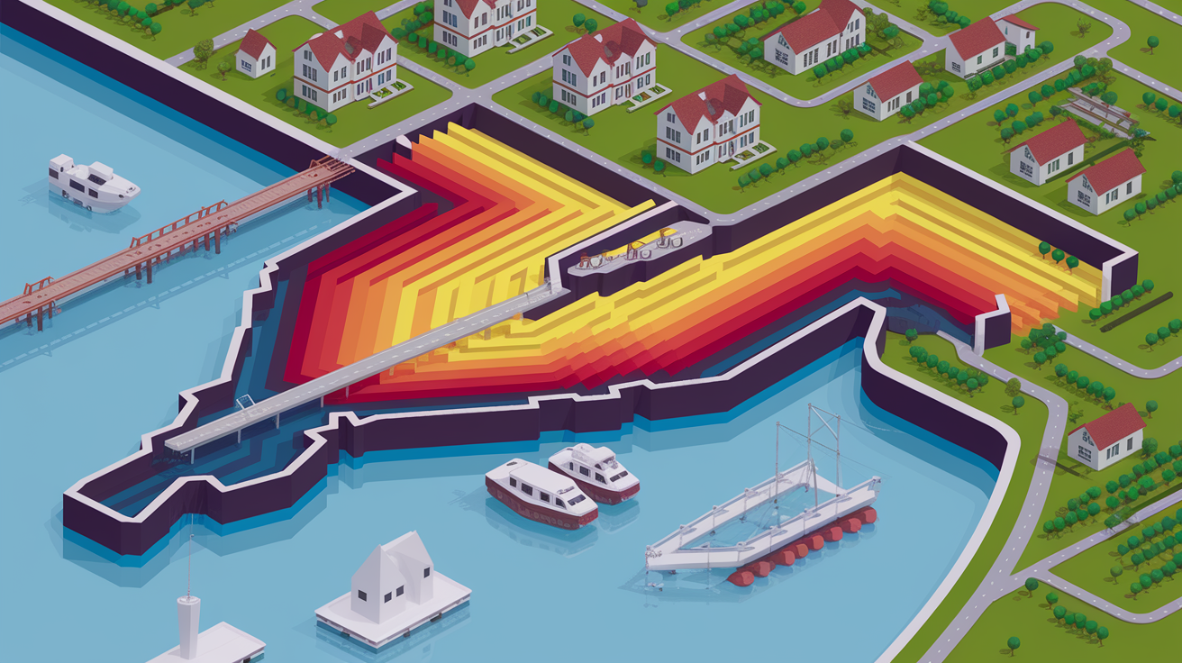
Elevation and how close you are to water bodies determine hazard zone designations that trigger different evacuation protocols. FEMA maps coastal Special Flood Hazard Areas into three zones based on wave risk and distance from shore. VE zones face the highest risk from wave action and storm surge, AE zones experience flooding but less severe wave impact, and AO zones see shallow flooding from sheet flow. Emergency managers order evacuations for VE zones first, sometimes days before a storm, while AE zones may receive evacuation orders 12 to 24 hours later.
Evacuation route capacity creates bottlenecks that force earlier departure orders in congested areas. Officials calculate how many hours it takes to move entire populations through limited road networks and across bridges that become impassable once winds exceed 40 miles per hour. Coastal communities connected to mainland areas by only one or two bridges face earlier evacuation deadlines than inland towns with multiple exit routes. Road closures from flooding or accidents multiply delays, turning three hour evacuation drives into eight hour ordeals.
Urban and rural settings present opposite challenges. High population density in cities means more people competing for the same evacuation routes, creating traffic congestion that slows everyone. Building elevation and structural safety in newer urban apartment buildings sometimes enable vertical evacuation, where residents move to upper floors instead of leaving the area entirely. Rural areas offer less traffic but longer distances to reach safe zones, fewer shelter options, and more dirt roads that become impassable in heavy rain. 7.3 million single and multifamily homes along Gulf and Atlantic Coasts are at risk of storm surge flood damage, with estimated reconstruction costs of nearly 1.8 trillion dollars.
| Geographic Factor | Impact on Evacuation |
|---|---|
| Coastal proximity (VE zone) | Requires earliest evacuation orders, often 48 to 72 hours before storm landfall |
| Low elevation areas | Higher flood risk triggers mandatory evacuation even for moderate storms |
| Urban high density settings | Traffic congestion extends evacuation time windows and requires earlier departure orders |
| Limited road network capacity | Creates bottlenecks that force staggered evacuation zone activation |
| Rural isolated communities | Longer travel distances and fewer shelters increase logistical complexity |
Official Warning Systems and Emergency Management Protocols

Emergency management agencies analyze flood predictions from meteorological services and hydrological models to determine when evacuation orders are necessary. They issue mandatory evacuation orders when flooding threatens life safety in specific zones, legally requiring departure, or voluntary evacuation recommendations when risk exists but remains lower. The distinction matters because mandatory orders trigger different legal protections and insurance implications.
Lead time and advance notice separate successful evacuations from disasters. Emergency managers aim to provide 24 to 48 hours of warning for river flooding and 48 to 72 hours for coastal hurricane evacuations, giving households time to prepare, secure property, arrange transportation, and reach safe locations before roads flood. Prediction accuracy determines how confidently officials can issue early warnings. When meteorologists predict a 90 percent probability of major flooding, managers order evacuations sooner than when confidence sits at 60 percent, even if the potential flood severity is identical.
Increasing frequency of high tide flooding events complicates warning protocols. Minor high tide flooding days in the U.S. increased to twice 2000 levels by 2021, averaging four days of flooding per year nationally. Cities like Boston, New York, and Norfolk, Virginia average more than ten days of high tide flooding per year, defined as coastal water reaching or exceeding 0.5 to 0.65 meters above the long term average daily highest tide. When flooding becomes routine, some residents ignore warnings, creating boy who cried wolf fatigue that reduces compliance when truly dangerous events approach.
Official warning systems include:
Emergency Alert System (EAS) broadcasts: Radio and television interruptions that reach audiences during normal programming, effective for those actively listening or watching media.
Wireless Emergency Alerts (WEA): Text messages sent to all mobile phones in threatened areas, bypassing the need for prior registration or app downloads.
Outdoor warning sirens and alarms: Audible alerts that notify people outdoors or those without access to electronic communications, though less effective in noisy urban environments.
Door to door notifications: Direct contact by emergency personnel or volunteers in high risk zones, most effective for reaching elderly residents and those without phones.
Social media alerts: Official emergency management posts on platforms like Facebook and X (formerly Twitter) that spread through sharing and reach tech connected populations quickly.
Traditional media coverage: News reports on television, radio, and newspapers that provide context and repeated warnings, particularly valuable for explaining evacuation routes and shelter locations.
Socioeconomic Barriers and Vulnerable Population Evacuation Challenges

Socioeconomic and demographic factors create compounded evacuation challenges that put disadvantaged populations at higher risk during floods. These barriers don’t exist alone. They interact to multiply difficulties for households already struggling with daily survival.
Financial resources affect every aspect of evacuation capacity. Immediate evacuation costs include fuel for vehicles, highway tolls on evacuation routes, temporary accommodation for days or weeks, restaurant meals when you can’t cook, lost wages from missing work, and kenneling fees when shelters don’t accept pets. Low income households are more likely to live in flood prone areas due to housing affordability constraints and are less likely to have flood insurance, limiting recovery options. Historical redlining practices and discrimination led racial minorities to disproportionately occupy flood prone low income areas. Financial constraints prevent low income households from evacuating to safer areas during flood events, creating a cruel choice between staying in danger or spending money they don’t have.
Vehicle availability and access to transportation determines who can leave and who gets stranded. Households without cars depend on rides from family, friends, or neighbors, public transportation that may shut down as flooding approaches, or emergency evacuation buses that serve only certain pickup points. Mobility constraints faced by elderly and disabled populations during evacuations include difficulties walking to bus stops, inability to stand in long lines, dependence on wheelchairs or walkers that don’t fit in some vehicles, reliance on medical equipment requiring electricity, and medication access concerns when pharmacies close. Older adults and those with chronic health conditions face evacuation difficulties and medical care access challenges during floods.
Homeownership versus rental status influences evacuation decisions in unexpected ways. Homeowners often delay leaving because they want to protect property investments, move furniture to higher floors, install flood barriers, or shut off utilities. Renters may evacuate more readily since they have less financial stake in the building, but they also lack authority to make property modifications and may fear landlords won’t refund rent for time away. Flood insurance coverage shapes decisions too. FEMA requires flood insurance for properties in Special Flood Hazard Areas with federally backed mortgages, but many homeowners in moderate risk zones skip coverage due to cost, making them more desperate to stay and protect uninsured assets.
Vulnerable population categories face specific evacuation barriers:
Low income households lacking financial resources for fuel, lodging, and meals and often without personal vehicles for transportation.
Elderly residents with mobility issues, medication dependencies, chronic health conditions requiring medical equipment, and difficulty processing rapid evacuation instructions.
Disabled populations requiring wheelchair accessible vehicles and shelters, assistance with daily activities, and specialized medical care that may be unavailable at evacuation sites.
Families with young children needing car seats, formula, diapers, and childcare when schools close, plus supervision challenges when both parents work.
Chronically ill individuals depending on oxygen tanks, dialysis machines, insulin refrigeration, and regular medication schedules that break down during evacuations.
Non English speakers facing language barriers that prevent understanding of evacuation warnings, route instructions, and shelter registration procedures.
Pet owners needing animal friendly evacuation options since many emergency shelters prohibit pets, forcing owners to choose between family members and safety.
Psychological and Behavioral Factors in Evacuation Compliance

Risk perception shapes evacuation decisions differently across individuals facing identical flood threats. Some people overestimate danger and evacuate for minor flood warnings, while others underestimate severe risks and stay despite mandatory orders.
Previous flood experience cuts both ways in evacuation behavior. Households that survived past floods sometimes feel confident they can weather the next one, creating false security based on outdated data or luck rather than preparation. Others who experienced flooding trauma evacuate at the first warning, having learned that official predictions can underestimate actual impacts. The memory of sitting on a roof waiting for rescue or losing irreplaceable possessions makes some families hair trigger ready to leave, while those who endured past evacuations that turned out unnecessary become skeptical of future warnings.
Optimism bias and denial behavior lead some residents to ignore evacuation warnings even when evidence mounts. People think floods happen to others, not me, or my house has never flooded in 30 years. This cognitive distortion intensifies when preparing for evacuation requires admitting you might lose your home or when you desperately want to believe the storm will weaken or shift course. Trust in authorities serves as a critical factor in evacuation compliance. Communities with long standing positive relationships with emergency management officials respond faster to warnings than areas where residents distrust government or have seen past false alarms. If officials cried wolf before, or if warnings seem inconsistent with what residents observe outside their windows, compliance drops.
Family influences, social networks, and community ties affect decisions to stay or leave through both helpful and harmful channels. When trusted neighbors or extended family members decide to evacuate, others follow. When community leaders or respected elders choose to stay, their decisions sway others despite official warnings. Fear and anxiety function as both motivators for evacuation and barriers when they create paralysis. Moderate fear prompts protective action like packing emergency kits and gassing up cars, but extreme anxiety overwhelms decision making ability, leaving people frozen and unable to act. Protective action depends on believing three things at once: the threat is real, the threat is severe enough to warrant disruption, and you personally face danger, not just people in general or on television.
Shelter Availability and Temporary Accommodation Factors
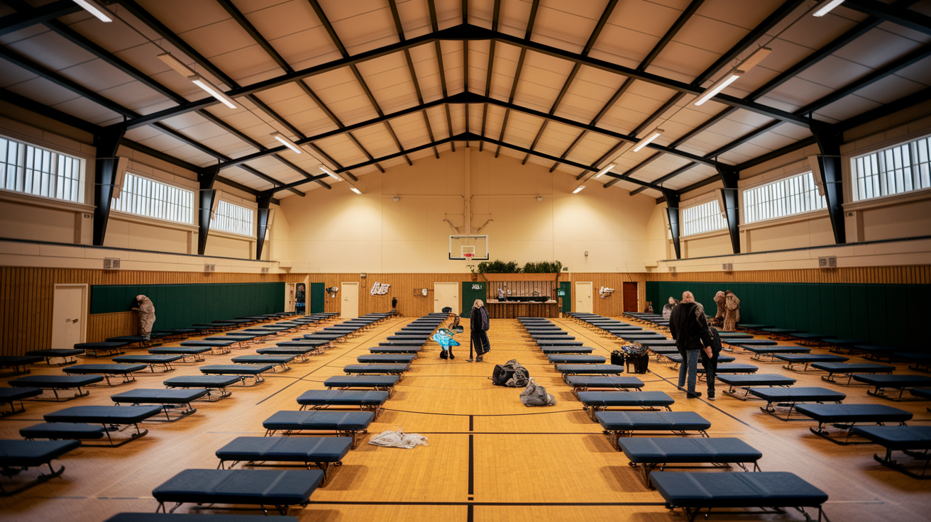
Emergency shelter capacity and location affect willingness to evacuate because people need to know where they’ll sleep before they agree to leave home. Shelters located 200 miles from the flood zone feel safer but create longer drives and higher fuel costs than facilities 50 miles away. When nearby shelters fill quickly, latecomers face uncertainty about finding space, which discourages departure.
Concerns about shelter conditions create evacuation hesitation that keeps people in harm’s way. Emergency shelters typically provide cots in shared gymnasiums or community centers with minimal privacy, communal bathrooms, limited electrical outlets, and basic meals. Some people choose flood risk over sleeping in a room with 200 strangers. Safety worries about theft or personal harm in crowded shelters particularly affect women traveling alone, families with young children, and elderly residents.
Temporary accommodation costs and pet friendly options present interconnected challenges. Hotel rooms during evacuations cost 100 to 200 dollars per night when available, adding up to thousands of dollars over multi week displacements. Many budget motels and hotels refuse pets, forcing owners to choose between family animals and safe shelter. Some families stay home rather than abandon dogs or cats. Property protection concerns make people reluctant to leave homes unattended, particularly given that 7.3 million single and multifamily homes along Gulf and Atlantic Coasts are at risk of storm surge flood damage with estimated reconstruction costs of nearly 1.8 trillion dollars. Residents worry about looting, wind damage allowing rain intrusion, utility failures causing secondary damage, or missing the chance to pump water before it rises too high. Having a flood emergency kit ready reduces some preparation stress but doesn’t eliminate property worries.
Key shelter related considerations include:
Distance to available shelters. Closer facilities encourage evacuation while distant options require more fuel, time, and commitment to leave.
Pet accommodation policies. Shelters accepting animals remove a major barrier for the estimated 67 percent of U.S. households that own pets.
Medical facility access. Evacuees with chronic conditions need shelters near hospitals or with on site medical staff for medication management and emergency care.
Duration limits for stays. Some shelters cap residence at 3 to 7 days, creating stress for evacuees whose homes remain flooded or damaged longer.
Privacy and security concerns. Shelters offering family partitions, separate sleeping areas for women and children, and security personnel increase willingness to evacuate.
Timing Considerations and Seasonal Evacuation Factors

Lead time determines whether evacuations happen smoothly or turn into desperate last minute escapes. Officials need 12 to 24 hours minimum to move populations safely, but 48 to 72 hours works better for large coastal cities where millions must travel the same highways.
Nighttime evacuations create hazards that daylight operations avoid. Drivers can’t see flooded road sections until they’re already in the water, emergency personnel have difficulty spotting stranded motorists, and families struggle to keep track of children during dark roadside stops. Traffic accidents multiply when tired drivers navigate unfamiliar evacuation routes in darkness. Daylight hours provide better visibility and safer conditions, which is why emergency managers try to time mandatory evacuation orders so departures happen during morning and afternoon rather than overnight.
Seasonal factors complicate evacuation planning in tourist areas and northern climates. Beach communities that house 50,000 year round residents may hold 250,000 people during summer vacation season, multiplying evacuation timeframes and shelter needs. Winter weather in northern regions creates ice storms and snow that close evacuation routes or make driving treacherous even when flooding is the primary threat.
Evacuation capacity decreases when multiple communities evacuate simultaneously during regional flood events. Hurricane evacuations from the entire Gulf Coast or Florida peninsula overwhelm highway systems and fill shelters across multiple states. Hotels 300 miles inland book solid when everyone in a 500 mile coastal zone tries to reserve rooms on the same day. Emergency plans and disaster planning that account for these capacity limits lead officials to order evacuations in staggered waves, moving the highest risk zones first and lower risk areas later. Nine out of the top 10 years for single day extreme precipitation events have occurred since 1996, and extreme precipitation is increasing by half a percentage point per decade across the U.S., meaning officials face more frequent decisions about evacuation timing. Adequate advance notice allows households to implement prepared emergency plans rather than making rushed decisions without necessary supplies. Evacuation drills and disaster planning improve timing and efficiency by teaching people their routes, testing how long movements actually take, and identifying bottlenecks before real emergencies. High tide floods are expected to rise from approximately 4 per year currently to more than 10 by 2050, increasing the frequency of evacuation decisions.
Risk Communication and Public Education Impact on Evacuation Behavior

Clear, consistent risk communication builds public understanding of flood threats by translating complex meteorological data into actionable protective guidance. When officials explain why a Category 3 hurricane requires evacuation but a Category 1 storm needs only preparation, residents develop better mental models for assessing future events. Messages that state specific dangers like water will reach 6 feet deep in this neighborhood create urgency better than vague warnings about potential flooding.
Public education campaigns improve evacuation preparedness and reduce decision making delays by teaching households what to pack, where to go, and how to shut off utilities before leaving. Communities with regular flood safety education programs evacuate 30 to 40 percent faster than areas where residents only hear warnings during actual emergencies. The increasing use of flood maps and risk assessment tools available to homeowners helps families understand their personal vulnerability. First Street Foundation created flood risk factors for individual properties nationwide, available through Realtor.com and Redfin, allowing people to see their flood risk before buying homes and to evaluate whether they live in areas requiring evacuation during different flood scenarios. FEMA is developing Risk Rating 2.0 as a new pricing mechanism for flood insurance to better reflect risk, which helps homeowners understand their actual exposure. Media coverage and social media alerts expand warning reach beyond official emergency management channels. Television news provides repeated visual information about storm tracks and flood predictions. Social media posts from trusted local sources, neighbors, and family members reinforce official messages and spread shelter information, road closure updates, and real time conditions faster than formal systems. A median eightfold increase is expected by 2050 in floods exceeding the 100 year flood event threshold, making ongoing public education increasingly critical.
| Communication Method | Effectiveness Factor |
|---|---|
| Official emergency management warnings | High credibility but limited reach to those not actively monitoring alerts |
| Television and radio media coverage | Broad reach with visual context but requires audience to be tuned in |
| Social media alerts and community posts | Rapid spread and peer reinforcement but variable accuracy and potential misinformation |
| Public education campaigns (pre-event) | Builds long term preparedness and reduces panic but requires sustained funding and participation |
Well informed communities evacuate more efficiently because education transforms abstract warnings into concrete steps people already know how to take.
Final Words
Your evacuation decision gets shaped by dozens of moving pieces working together, not just one alarm or weather report.
What factors determine flood evacuation? Physical conditions like water predictions, your geographic location, official warnings, your financial reality, how you assess risk, shelter options, timing windows, and how clearly information reaches you.
None of these work alone. They stack and interact.
The more you understand what drives these decisions, both for officials and for your household, the faster you can act when it matters. You’ll know what to watch for, what questions to ask, and which steps to take first.
That preparation gives you back control when everything else feels uncertain.
FAQ
What are the 5 P’s of emergency?
The 5 P’s of emergency are people, prescriptions, papers, personal needs, and priceless items. This checklist helps you grab the most important things fast during an evacuation, covering family members, medications, documents, essentials like phone chargers, and items with sentimental value you can’t replace.
What does a 7 out of 10 flood factor mean?
A 7 out of 10 flood factor means a property has substantial flood risk compared to other properties. This rating, created by flood risk assessment tools like First Street Foundation, indicates the property faces higher likelihood of flooding than most homes and may need serious flood preparation and insurance consideration.
What determines an evacuation zone?
Evacuation zones are determined by elevation, distance from coastlines and water bodies, storm surge risk potential, and infrastructure isolation factors. Emergency managers use these geographic characteristics to map areas most vulnerable to flooding, with coastal zones rated by wave action susceptibility and inland zones rated by river proximity.
What are the 5 stages of the evacuation process?
The 5 stages of the evacuation process are decision (officials assess threat), warning (authorities issue alerts), preparation (households gather supplies and secure property), movement (people travel to safe locations), and return (residents come back when officials clear the area). Each stage requires specific actions and timing.